samedi 21 février 2009

Why is the ocean salty?

salt.gif (5204 bytes)
Why is the Ocean Salty?

By Herbert Swenson
US Geological Survey Publication


All water, even rain water, contains dissolved chemicals which scientists call "salts." But not all water tastes salty. Water is fresh or salty according to individual judgment, and in making this decision man is more convinced by his sense of taste than by a laboratory test. It is one's taste buds that accept one water and reject another.


A simple experiment illustrates this. Fill three glasses with water from the kitchen faucet. Drink from one and it tastes fresh even though some dissolved salts are naturally present. Add a pinch of table salt to the second, and the water may taste fresh or slightly salty depending on a personal taste threshold and on the amount of salt held in a "pinch." But add a teaspoon of salt to the third and your taste buds vehemently protest that this water is too salty to drink; this glass of water has about the same salt content as a glass of sea water.


Obviously, the ocean, in contrast to the water we use daily, contains unacceptable amounts of dissolved chemicals; it is too salty for human consumption.

HOW SALTY IS THE OCEAN?...


How salty the ocean is, however, defies ordinary comprehension. Some scientists estimate that the oceans contain as much as 50 quadrillion tons (50 million billion tons) of dissolved solids.

If the salt in the sea could be removed and spread evenly over the Earth's land surface it would form a layer more than 500 feet thick, about the height of a 40-story office building. The saltiness of the ocean is more understandable when compared with the salt content of a fresh-water lake. For example, when 1 cubic foot of sea water evaporates it yields about 2.2 pounds of salt, but 1 cubic foot of fresh water from Lake Michigan contains only one one-hundredth (0.01) of a pound of salt, or about one sixth of an ounce. Thus, sea water is 220 times saltier than the fresh lake water. What arouses the scientist's curiosity is not so much why the ocean is salty, but why it isn't fresh like the rivers and streams that empty into it. Further, what is the origin of the sea and of its "salts"? And how does one explain ocean water's remarkably uniform chemical composition? To these and related questions, scientists seek answers with full awareness that little about the oceans is understood.

figure.gif (57527 bytes)


Illustration: Sources of salts in the ocean.

THE ORIGIN OF THE SEA...


In popular language, "ocean" and "sea" are used interchangeably. Today's seas are the North and South Pacific, North and South Atlantic, Indian and Arctic Oceans and the Antarctic waters or seas.


Scientists believe that the seas are as much as 500 million years old because animals that lived then occur as fossils in rocks which once were under ancient seas. There are several theories about the origin of the seas, but no single theory explains all aspects of this puzzle. Many earth scientists agree with the hypothesis that both the atmosphere and the oceans have accumulated gradually through geologic time from some process of "degassing" of the Earth's interior. According to this theory, the ocean had its origin from the prolonged escape of water vapor and other gases from the molten igneous rocks of the Earth to the clouds surrounding the cooling Earth. After the Earth's surface had cooled to a temperature below the boiling point of water, rain began to fall and continued to fall for centuries. As the water drained into the great hollows in the Earth's surface, the primeval ocean came into existence. The forces of gravity prevented the water from leaving the planet.

SOURCES OF THE SALTS...


Sea water has been defined as a weak solution of almost everything. Ocean water is indeed a complex solution of mineral salts and of decayed biologic matter that results from the teeming life in the seas. Most of the ocean's salts were derived from gradual processes such the breaking up of the cooled igneous rocks of the Earth's crust by weathering and erosion, the wearing down of mountains, and the dissolving action of rains and streams which transported their mineral washings to the sea. Some of the ocean's salts have been dissolved from rocks and sediments below its floor. Other sources of salts include the solid and gaseous materials that escaped from the Earth's crust through volcanic vents or that originated in the atmosphere.

IF FRESH WATER FLOWS OUT TO THE SEA, WHY IS THE SEA STILL SALTY?...


The Mississippi, Amazon, and Yukon Rivers empty respectively into the Gulf of Mexico, the Atlantic Ocean, and the Pacific Ocean, all of which are salty. Why aren't the oceans as fresh as the river waters that empty into them? Because the saltiness of the ocean is the result of several natural influences and processes, the salt load of the streams entering the ocean is just one of these factors.

In the beginning the primeval seas must have been only slightly salty. But ever since the first rains descended upon the young Earth hundreds of millions of years ago and ran over the land breaking up rocks and transporting their minerals to the seas, the ocean has become saltier. It is estimated that the rivers and streams flowing from the United States alone discharge 225 million tons of dissolved solids and 513 million tons of suspended sediment annually to the sea. Recent calculations show yields of dissolved solids from other land masses that range from about 6 tons per square mile for Australia to about 120 tons per square mile for Europe. Throughout the world, rivers carry an estimated 4 billion tons of dissolved salts to the ocean annually. About the same tonnage of salt from the ocean water probably is deposited as sediment on the ocean bottom, and thus, yearly gains may offset yearly losses. In other words, the oceans today probably have a balanced salt input and outgo.

Past accumulations of dissolved and suspended solids in the sea do not explain completely why the ocean is salty. Salts become concentrated in the sea because the Sun's heat distills or vaporizes almost pure water from the surface of the sea and leaves the salts behind. This process is part of the continual exchange of water between the Earth and the atmosphere that is called the hydrologic cycle. Water vapor rises from the ocean surface and is carried landward by the winds. When the vapor collides with a colder mass of air, it condenses (changes from a gas to a liquid) and falls to Earth as rain. The rain runs off into streams which in turn transport water to the ocean. Evaporation from both the land and the ocean again causes water to return to the atmosphere as vapor and the cycle starts anew. The ocean, then, is not fresh like river water because of the huge accumulation of salts by evaporation and the contribution of raw salts from the land. In fact, since the first rainfall, the seas have become saltier.

SEA WATER IS NOT SIMPLE...


Scientists have studied the ocean's water for more than a century, but they still do not have a complete understanding of its chemical composition. This is partly due to the lack of precise methods and procedures for measuring the constituents in sea water. Some of the problems confronting scientists stem from the enormous size of the oceans, which cover about 70 percent of the Earth's surface, and the complex chemical system inherent in a marine environment in which constituents of sea water have intermingled over vast periods of time. At least 72 chemical elements have been identified in sea water, most in extremely small amounts. Probably all the Earth's naturally occurring elements exist in the sea. Elements may combine in various ways and form insoluble products (or precipitates) that sink to the ocean floor. But even these precipitates are subject to chemical alteration because of the overlying sea water which continues to exert its environmental influence.

SALINITY AND ITS VARIABILITY...


Oceanographers report salinity (total salt content) and the concentrations of individual chemical constituents in sea water -- chloride, sodium, or magnesium for example -- in parts per thousand, for which the symbol o/oo is used. That is, a salinity of 35 o/oo means 35 pounds of salt per 1,000 pounds of sea water. Similarly, a sodium concentration of 10 o/oo means 10 pounds of sodium per 1,000 pounds of water.

The salinity of ocean water varies. It is affected by such factors as melting of ice, inflow of river water, evaporation, rain, snowfall, wind, wave motion, and ocean currents that cause horizontal and vertical mixing of the saltwater.

THE SALTIEST WATER...


The saltiest water (40 o/oo ) occurs in the Red Sea and the Persian Gulf, where rates of evaporation are very high. Of the major oceans, the North Atlantic is the saltiest; its salinity averages about 37.9 o/oo. Within the North Atlantic, the saltiest part is the Sargasso Sea, an area of about 2 million square miles, located about 2,000 miles west of the Canary Islands. The Sargasso Sea is set apart from the open ocean by floating brown seaweed "sargassum" from which the sea gets its name. The saltiness of this sea is due in part to the high water temperature (up to 83º F) causing a high rate of evaporation and in part to its remoteness from land; because it is so far from land, it receives no fresh-water inflow.

Low salinities occur in polar seas where the salt water is diluted by melting ice and continued precipitation. Partly landlocked seas or coastal inlets that receive substantial runoff from precipitation falling on the land also may have low salinities. The Baltic Sea ranges in salinity from about 5 to 15 o/oo. The salinity of the Black Sea is less than 20 o/oo. Water of the Puget Sound in the Tacoma, Wash., area ranges in salt content from 21 to about 27 o/oo. This area is drained by a number of fresh-water streams which discharge an average of about 4.1 billion gallons of water per day into Puget Sound. Salinity of sea water along the coastal areas of the conterminous United States varies with the month of the year as well as with geographic location. For example, the salinity of the ocean water off Miami Beach, Fla., varies from about 34.8 o/oo in October to 36.4 o/oo in May and June, while diagonally across the country, off the coast of Astoria, Oregon, the salinity of sea water varies from 0.3 o/oo in April and May to 2.6 o/oo in October. The water off the coast of Miami Beach has a high salt content because it is undiluted sea water. Off the coast of Astoria, however, the sea water is less saline because it is mixed with the fresh water of the mighty Columbia.

Sometimes river water travels far from shore before it mixes with sea water. This is shown by data gathered from a study of the Columbia River, which, in an average year, carries to the ocean enough water to cover an area of 1 million acres to a depth of 197 feet. Using a radio- active tracer, scientists at Oregon State University have followed the river's water from its mouth near Astoria to a point southwest of Coos Bay, 217 miles away.

The salt content of the open oceans, free from land influences, is rarely less than 33 o/oo and seldom more than 38 o/oo. Throughout the world, the salinity of sea water averages about 35 o/oo. This average salinity was obtained by William Dittmar in 1884 from chemical analyses of 77 sea water samples collected from many parts of the world during the scientific expedition of the British corvette, H.M.S. Challenger. The Challenger expedition, organized by the British Government at the suggestion of the Royal Society, set out to study the biology of the sea, examine the chemical and physical properties of the water, sample deposits on the ocean floor, and measure water temperatures. The voyage began in 1872 and ended almost 4 years later after covering 68,890 nautical miles. This expedition remains today the longest continuous scientific investigation of the ocean basins. Dittmar's 77 samples are still the only worldwide set of samples of sea water for which complete data (each principal constituent) on chemical composition are available. More recent data, reflecting improvements in analytical and sampling techniques, show slight deviations from Dittmar's results, but these changes do not affect the overall usefulness of his work. The average composition of the 77 samples is as shown on the following table.


charts.gif (76759 bytes)

The salinity of water in the open sea is not fixed at 35 o/oo even in areas distant from land; that figure is only an average. On a worldwide basis, a maximum salinity of 36 o/oo occurs at about latitudes 20º N. and 20º S. The average salinity of sea water, 35 o/oo , occurs at the Equator. A minimum salinity of 31 o/oo corresponds approximately with latitude 60º N., whereas lowest salinities of 33 o/oo in the Southern Hemisphere occur at latitude 60º S. At the Equator, where salinity is 35 o/oo, the dilution of sea water by rain is offset by the loss of water by evaporation. But in the latitudes bordering the Equator the opposite condition prevails -- evaporation exceeds rainfall because high temperatures plus increased winds accelerate evaporation losses.


HOW SEA LIFE AFFECTS SEA WATER'S COMPOSITION...


Inasmuch as the oceans receive most of their water from the rivers, the ratios (as distinguished from the total amounts) of different chemical constituents should be about the same in both regardless of total salt content. But this is not so. Comparisons of Dittmar's data on ocean water with the average salt concentrations in river waters of the world is as shown on the preceding table (above).


Sea water and river water obviously are very different from each other:


(1) Sodium and chloride (the components of common table salt) constitute a little more than 85 percent of the dissolved solids in ocean water and give to the water its characteristic salty taste, but they represent less than 16 percent of the salt content of river water.

(2) Rivers carry to the sea more calcium than chloride, but the oceans nevertheless contain about 46 times more chloride than calcium.

(3) Silica is a significant constituent of river water but not of sea water.

(4) Calcium and bicarbonate account for nearly 50 percent of the dissolved solids in river water yet constitute less than 2 percent of the dissolved solids in ocean water. These variations seem contrary to what one would expect.

Part of the explanation is the role played by marine life -- animals and plants -- in ocean water's composition. Sea water is not simply a solution of salts and dissolved gases unaffected by living organisms in the sea. Mollusks (oysters, clams, and mussels, for example) extract calcium from the sea to build their shells and skeletons. Foraminifers (very small one-celled sea animals) and crustaceans (such as crabs, shrimp, lobsters, and barnacles) likewise take out large amounts of calcium salts to build their bodies. Coral reefs, common in warm tropical seas, consist mostly of limestone (calcium carbonate) formed over millions of years from the skeletons of billions of small corals and other sea animals. Plankton (tiny floating animal and plant life) also exerts control on the composition of sea water. Diatoms, members of the plankton community, require silica to form their shells and they draw heavily on the ocean's silica for this purpose.

Some marine organisms concentrate or secrete chemical elements that are present in such minute amounts in sea water as to be almost undetectable: Lobsters concentrate copper and cobalt; snails secrete lead; the sea cucumber extracts vanadium; and sponges and certain seaweeds remove iodine from the sea.

Sea life has a strong influence on the composition of sea water. However, some elements in sea water are not affected to any apparent extent by plant or animal life. For example, no known biological process removes the element sodium from the sea.

In addition to biological influences, the factors of solubility and physical-chemical reaction rates also help to explain the composition of sea water. The solubility of a constituent may limit its concentration in sea water. Excess calcium (more calcium than the water can hold) may be precipitated out of the water and deposited on the sea floor as calcium carbonate. Presumably as a result of physical-chemical reactions not well understood, the metal manganese occurs as nodules in many places on the ocean floor. Similarly, phosphorite (phosphate rock) is found in large amounts on the sea bottom off southern California and in lesser amounts in several other places.

NEAR-CONSTANT RATIOS OF MAJOR CONSTITUENTS...


Although the composition of sea water differs from that of river water, the proportions of the major constituents of sea water are almost constant throughout the world. Dittmar's 77 samples showed no significant global differences in relative composition, and his average concentrations are used today to represent the ratios of major constituents in sea water. The analyses, which Dittmar made over a period of 9 years, further showed that chloride, sodium, magnesium, sulfate, calcium, and potassium make up 99 percent of the dissolved solids in sea water. Dittmar's findings may be expressed in another way: although the salinity or total salt content may vary from place to place, the ratio of any one major constituent of sea water (chloride as an example) to the total content is nearly constant. However, the ratios of the less abundant elements (aluminum, copper, tin, and bismuth, for example) to total salt content are not constant nor are those of dissolved gases such as oxygen, carbon dioxide, and nitrogen. But establishment of the near constancy of the ratios of major constituents of sea water is important because it enables scientists to measure one principal element and then, by projection of ratios and correction for temperature and pressure, to calculate the other components in the water, thereby determining its salinity.

SUMMARY...


The ocean is salty because of the gradual concentration of dissolved chemicals eroded from the Earth's crust and washed into the sea. Solid and gaseous ejections from volcanoes, suspended particles swept to the ocean from the land by onshore winds, and materials dissolved from sediments deposited on the ocean floor have also contributed. Salinity is increased by evaporation or by freezing of sea ice and it is decreased as a result of rainfall, runoff, or the melting of ice. The average salinity of sea water is 35 o/oo, but concentrations as high as 40 o/oo are observed in the Red Sea and the Persian Gulf. Salinities are much less than average in coastal waters, in the polar seas, and near the mouths of large rivers.

Sea water not only is much saltier than river water but it also differs in the proportion of the various salts. Sodium and chloride constitute 85 percent of the dissolved solids in sea water and account for the characteristic salty taste. Certain constituents in sea water, such as calcium, magnesium, bicarbonate, and silica, are partly taken out of solution by biological organisms, chemical precipitation, or physical-chemical reactions. In open water the chemical composition of sea water is nearly constant. Because of the stable ratios of the principal constituents to total salt content, the determination of one major constituent can be used to calculate sea water salinity. For minor constituents and dissolved gases the composition is variable and therefore ratios cannot be used to calculate salt Circulation and mixing, density and ocean currents, wind action, water temperature, solubility, and biochemical reactions are some of the factors that explain why the composition of water in the open sea is almost constant from place to place.

This information is from a general interest publication ("Why is the Ocean Salty?" By Herbert Swenson) prepared by the U.S. Geological Survey to provide information about the earth sciences, natural resources, and the environment.

To obtain a catalog of additional titles in the series "General Interest Publications of the U.S. Geological Survey," write:


U.S. Geological Survey


Branch of Distribution


P.O. Box 25286


Denver, CO 80225


For sale by the U.S. Government Printing Office Superintendent of Documents, Mail Stop: SSOP, Washington, DC 20402-9328

Illustrate sea-floor spreading and subduction by building a model

How to Build a Model Illustrating Sea-Floor Spreading and Subduction

Sea-floor spreading model

by

John C. Lahr

Open-File Report 99-132, On-Line Edition

(MS Word97 Version for Printing)

This report is preliminary and has not been reviewed for conformity with U.S. Geological Survey editorial standards. Any use of trade, product, or firm names is for descriptive purposes only and does not imply endorsement by the U.S. Government.


Denver Federal Center
Box 25946, Mail Stop 966
Denver, CO 80225
Phone: (303) 273-8596
Email: lahr@usgs.gov

Introduction

This report describes how to build a model of the outer 300 km (180 miles) of the Earth that can be used to develop a better understanding of the principal features of plate tectonics, including sea-floor spreading, the pattern of magnetic stripes frozen into the sea floor, transform faulting, thrust faulting, subduction, and volcanism.

In addition to a paper copy of this report, the materials required are a cardboard shoebox, glue, scissors, straight edge, and safety razor blade.

Structure of the Earth

The Earth consists of an iron-rich core with a radius of 3,500 km (2,100 miles), surrounded by a 2,800-km- (1,680-mile-) thick mantle of mostly silicon, magnesium, and oxygen, and finally an 80-km- (50-mile-) thick lithosphere. While 96% of the volume of the core is liquid, there is a solid inner core with a radius of 1,200 km (720 miles). Electric currents within the metallic-liquid outer core create the Earth's magnetic field. This magnetic field is oriented approximately parallel to the rotation pole of the Earth.

Structure of the Earth

.

Plate Tectonics

The mantle, which is much more solid than the outer core, is slowly convecting due to the increase of temperature with depth within the Earth. This motion can be compared to the convective motion of water in a pan that is being heated on a stove; however, the movement of the mantle is much, much slower. The lithosphere, the outer hard shell of the Earth, is broken into a dozen or so major pieces, called plates, and these plates are moving with respect to one another. At one time North America, South America, Europe, and Africa were joined together in one giant continent that has since broken apart to form the Atlantic Ocean Basin. The following figure (Stacy, 1977) shows how these plates once fit together.

Plate Tectonics

The process of sea-floor spreading created the lithosphere under the Atlantic Ocean. As North America and South America moved away from Europe and Africa, the resulting crack was filled by mantle material, which cooled and formed new lithosphere. The process continues today. Molten mantle materials continually rise to fill the cracks formed as the plates move slowly apart from each other. This process creates an underwater mountain chain, known as a mid-ocean ridge, along the zone of newly forming lithosphere.

Magnetic Stripes

Molten rock erupts along a mid-ocean ridge, then cools and freezes to become solid rock. The direction of the magnetic field of the Earth at the time the rock cools is "frozen" in place. This happens because magnetic minerals in the molten rock are free to rotate so that they are aligned with the Earth's magnetic field. After the molten rock cools to a solid, these minerals can no longer rotate freely. At irregular intervals, averaging about 200-thousand years, the Earth's magnetic field reverses. The end of a compass needle that today points to the north will instead point to the south after the next reversal. The oceanic plates act as a giant tape recorder, preserving in their magnetic minerals the orientation of the magnetic field present at the time of their creation. Geologists call the current orientation "normal" and the opposite orientation "reversed."

In the figure below, two plates are moving apart. A mid-ocean ridge marks the location where molten rocks are moving up, cooling, and forming new ocean floor. The zones of normal magnetization are indicated by ////// shading of the oceanic crust.

Magnetic Stripes

The figure below shows the observed magnetic pattern along the mid-Atlantic Ridge south of Iceland. This figure is from the excellent publication "A Teacher's Guide to the Geology of Hawaii Volcanoes National Park" (Mattox, 1992), which is available on the World Wide Web at http://volcano.und.nodak.edu/vwdocs/vwlessons/plate_tectonics/part9.html. The Guide starts at http://volcano.und.nodak.edu/vwdocs/vwlessons/atg.html .

Based on the pattern and spacing of the oceanic magnetic stripes and the inferred motion of the plates, the age of the ocean floor can be determined. In the figure below by Müller and others (1997) ( http://gdcinfo.agg.emr.ca/app/jgr_paper.html ), the age of the ocean floor is depicted by colors (http://gdcinfo.agg.emr.ca/app/images/agemap.GIF ).

Digital isocrons of the ocean floor

Convergent Margins

In some places, oceanic plates collide with continental plates. When this occurs, the heavier oceanic lithosphere sinks beneath the continental plate. This process, called subduction, creates a very deep trough near the line of contact between the oceanic and continental plates. This trough is called an oceanic trench. As an oceanic plate is subducted into the Earth it is subjected to increased pressure and temperature. These conditions cause some lightweight materials to melt and rise to the surface to form volcanoes. As a result, long chains of volcanoes, called volcanic arcs, are located above subducted plates, usually above the location where the plate has reached a depth of about 100 km.

Convergent Margins

Earthquakes

Geologic deformation is usually very slow, measured in centimeters per year, so the dynamic processes that continually reshape the Earth are, for the most part, unnoticed. Earthquakes are an occasional reminder that this deformation is indeed taking place, and infrequent, but potentially damaging, large earthquakes pose a hazard that is all too often ignored.

Earthquakes occur wherever two plates slip past one another, such as along the San Andreas Fault in California. This type of faulting is called "strike-slip." Earthquakes also occur where one plate slides under the other, as is happening in southern Alaska. "Thrust" earthquakes have been responsible for the two largest earthquakes ever recorded, the 1960 M 9.5 Chile earthquake and the 1964 M 9.2 Alaska earthquake. Pull-apart earthquakes occur where the lithosphere is being stretched, such as along mid-ocean ridges. These earthquakes generate "normal-faulting" events. When two ridges are connected by a fault, this is called a transform fault, and the fault is the source of strike-slip events.

When completed, your model will look something like the figure below. Follow the directions on the following pages to complete the model. Coloring with paint or magic markers can be

Completed model

added to enhance the model. Note that the shaded portions of the sea floor have the same magnetization as today, while the unshaded portions have reversed magnetization.

Operation of the Model

Slide the sea floor into the three slits in the shoebox and pull it down from underneath so that the numbers "4" are just visible. Slide the sea floor into the trench as well. This is the position the sea floor would have had 4 million years ago. Now slowly pull down with one hand on the sea floor beneath the trench, while pulling with the other hand on opposite end of the sea floor. As the sea floor diverges at the ridges, new sea floor will continually appear until the dark gray bands indicating the current epoch of normal magnetic polarity have been revealed.

Now move the sea floor back to the 4 my before present position, and this time, while the sea floor is moving, watch the boundaries where slip is occurring. Where would the three styles of earthquake -- namely thrust, normal, and strike-slip -- occur?

The USGS National Earthquake Information Center has placed seismicity maps for many regions of the World on their World Wide Web site: http://gldss7.cr.usgs.gov/neis/general/seismicity/seismicity.html . Look at some of these maps and see if you can tell where the plate boundaries are located. Where are the deepest earthquakes located and why are they there?

From the ages of the sea floor and the scale of the model, which is the same in the vertical and horizontal directions, one can determine that the plate in this model is being subducted at a rate of about 50 km/my. This works out to 5 cm/y, which is within the 1 to 10 cm/y range that most plates are moving. As an interesting comparison, this is about the rate that fingernails grow!

Suggested Additional Reading

Kious, W. J., and Tilling, R I., 1992, This Dynamic Earth, The Story of Plate Tectonics, U. S. Geological Survey, Booklet 92-TDE, 77 p.

This publication can be found on the World Wide Web at http://pubs.usgs.gov/publications/text/dynamic.html .

Acknowledgements

The author would like to acknowledge the careful reviews by E. Cranswick and P. Detra. In particular, the latter's suggestion to reduce the size of the model to that of a shoebox was most helpful.

References

Mattox, S. R., 1992, A teacher's guide to the geology of Hawaii Volcanoes National Park, published by the Hawaii Natural History Association, P.O. Box 74, Hawaii National Park, HI 96718, (808) 967-7604.

Müller, R. D., Roest, W. R., Royer, J.-Y., Gahagan, L. M., and Sclater, J. G., 1997, Digital isochrons of the World's ocean floor, Journal of Geophysical, V. 102 (B2), p. 3211-3214.

Stacey, F. D., 1977, Physics of the Earth, John Wiley & Sons, New York, 414 pages.

Sea-floor Spreading Model Directions

1) Use a shoe box with approximate dimensions 6.5" x 13" by 5" deep.

2) Trim as indicated the pages labeled "Left portion of side of shoe box" and "Right ...". Glue these two pages together to form the cross section through the Earth.

3) Turn the shoe box over, so that the opening is down. Glue the cross section sheets that you have just glued together to the long side of the shoe box. The surface of the ocean should be even with the top of the shoe box while the volcano
wiill stick up a bit.

Sea-Floor spreading model directions.

4) Trim as indicated the pattern for cutting slits in the shoe box. Orient the slit-pattern sheet as in the figure above, so that the mid-ocean ridge slit and the trench slit match the cross section on the side of the box. Cut the four slits through the shoe box. Discard the slit pattern and the four tabular pieces of cardboard from the slits.

5) Cut the four slits through the shoe box. Discard the slit pattern and the four tabular pieces of cardboard from the slits.

Sea-Floor spreading model directions continued.

How does the depth of the ocean affect its temperature?

Chapter 4 - Ocean Chemistry

Scientists use a variety of instruments to measure salinity, temperature, and oxygen in the world's oceans. This information is then used to generate Hydrographic maps that depict the physical and chemical structure of the world's oceans.

The temperature of the ocean generally decreases with depth. Why?

The highest average temperature is about 25 oC at the surface. This temperature can still be found at 50 m depth. However cooler temperatures occur off the west coast of South America at this depth. Why? At about 200 m depth the pools of 25 oC water have almost disappeared. By 600 m there are just traces in the western North Atlantic. One can see that the Pacific is colder than the Atlantic. By 1100 m the Pacific is generally <>oC. Interestingly one can see a tongue of warm water in the eastern Atlantic, near the mouth of the Mediterranean. Why? Are there any other pools of warm water? By 1750 m depth the water is generally <4>oC, but one can still see the tongues of warm water. Why? How great is the overall change in temperature with depth in the ocean?

The pattern for salinity is somewhat different. Take a look at the maps for the surface, 50 m, 200 m, 600 m, and 1100 m. Instead of generally decreasing with depth, salinity increases. Why? How great is the change in salinity? Is it as great as the temperature change? Why is there a tongue of high salinity water in the eastern North Atlantic? Are there any other areas that show a particularly high salinity?

Sound

The physical properties of seawater affect the transmission of sound. The speed of sound decreases with decreasing temperature and increases with increasing pressure. The relationship of these two factors results in a zone of minimum sound velocity in the ocean referred to as the SOFAR channel. This channel is important for a variety of reasons. Sound is used by a variety of marine organisms to communicate and it appears that many marine organisms use the SOFAR channel for this purpose.

Acoustic Thermometry is the field of study that relies on sound to measure the temperature of the oceans. Scientists have proposed using sound to assess global warming. This field experiment has generated quite a bit of controversy. In order to move forward with the experiment additional studies were needed to determine the potential impact on marine mammals.

Chemical resources

  • The ocean is a source of many natural chemical resources;
  • salt is one of them.

Hydrologic cycle

While 97% of the earth's surface water occurs in the oceans the remainder is found in several other reservoirs. In fact the water moves from reservoir to reservoir fueled by the energy from the sun. Water evaporates, is transported, and eventually returns to the earth's surface as precipitation. The movement between reservoirs is called the Hydrologic Cycle.

WHY IS THE SKY BLUE?

WHY IS THE SKY BLUE?


On a clear sunny day, the sky above us looks bright blue. In the evening, the sunset puts on a brilliant show of reds, pinks and oranges. Why is the sky blue? What makes the sunset red?

To answer these questions, we must learn about light, and the Earth's atmosphere.

THE ATMOSPHERE

The atmosphere is the mixture of gas molecules and other materials surrounding the earth. It is made mostly of the gases nitrogen (78%), and oxygen (21%). Argon gas and water (in the form of vapor, droplets and ice crystals) are the next most common things. There are also small amounts of other gases, plus many small solid particles, like dust, soot and ashes, pollen, and salt from the oceans.

The composition of the atmosphere varies, depending on your location, the weather, and many other things. There may be more water in the air after a rainstorm, or near the ocean. Volcanoes can put large amounts of dust particles high into the atmosphere. Pollution can add different gases or dust and soot.

The atmosphere is densest (thickest) at the bottom, near the Earth. It gradually thins out as you go higher and higher up. There is no sharp break between the atmosphere and space.

LIGHT WAVES

Light is a kind of energy that radiates, or travels, in waves. Many different kinds of energy travel in waves. For example, sound is a wave of vibrating air. Light is a wave of vibrating electric and magnetic fields. It is one small part of a larger range of vibrating electromagnetic fields. This range is called the electromagnetic spectrum.

Electromagnetic waves travel through space at 299,792 km/sec (186,282 miles/sec). This is called the speed of light.

Light waves

The energy of the radiation depends on its wavelength and frequency. Wavelength is the distance between the tops (crests) of the waves. Frequency is the number of waves that pass by each second. The longer the wavelength of the light, the lower the frequency, and the less energy it contains.

COLORS OF LIGHT

Visible light is the part of the electromagnetic spectrum that our eyes can see. Light from the sun or a light bulb may look white, but it is actually a combination of many colors. We can see the different colors of the spectrum by splitting the light with a prism. The spectrum is also visible when you see a rainbow in the sky.

Rainbow Picture

The colors blend continuously into one another. At one end of the spectrum are the reds and oranges. These gradually shade into yellow, green, blue, indigo and violet. The colors have different wavelengths, frequencies, and energies. Violet has the shortest wavelength in the visible spectrum. That means it has the highest frequency and energy. Red has the longest wavelength, and lowest frequency and energy.

LIGHT IN THE AIR

Light travels through space in a straight line as long as nothing disturbs it. As light moves through the atmosphere, it continues to go straight until it bumps into a bit of dust or a gas molecule. Then what happens to the light depends on its wave length and the size of the thing it hits.

Dust particles and water droplets are much larger than the wavelength of visible light. When light hits these large particles, it gets reflected, or bounced off, in different directions. The different colors of light are all reflected by the particle in the same way. The reflected light appears white because it still contains all of the same colors.

Gas molecules are smaller than the wavelength of visible light. If light bumps into them, it acts differently. When light hits a gas molecule, some of it may get absorbed. After awhile, the molecule radiates (releases, or gives off) the light in a different direction. The color that is radiated is the same color that was absorbed. The different colors of light are affected differently. All of the colors can be absorbed. But the higher frequencies (blues) are absorbed more often than the lower frequencies (reds). This process is called Rayleigh scattering. (It is named after Lord John Rayleigh, an English physicist, who first described it in the 1870's.)

WHY IS THE SKY BLUE?

The blue color of the sky is due to Rayleigh scattering. As light moves through the atmosphere, most of the longer wavelengths pass straight through. Little of the red, orange and yellow light is affected by the air.

However, much of the shorter wavelength light is absorbed by the gas molecules. The absorbed blue light is then radiated in different directions. It gets scattered all around the sky. Whichever direction you look, some of this scattered blue light reaches you. Since you see the blue light from everywhere overhead, the sky looks blue.

Blue sky from scattered light

As you look closer to the horizon, the sky appears much paler in color. To reach you, the scattered blue light must pass through more air. Some of it gets scattered away again in other directions. Less blue light reaches your eyes. The color of the sky near the horizon appears paler or white.

Sky paler at horizon

THE BLACK SKY AND WHITE SUN

On Earth, the sun appears yellow. If you were out in space, or on the moon, the sun would look white. In space, there is no atmosphere to scatter the sun's light. On Earth, some of the shorter wavelength light (the blues and violets) are removed from the direct rays of the sun by scattering. The remaining colors together appear yellow.

Also, out in space, the sky looks dark and black, instead of blue. This is because there is no atmosphere. There is no scattered light to reach your eyes.

Black sky in space

WHY IS THE SUNSET RED?

As the sun begins to set, the light must travel farther through the atmosphere before it gets to you. More of the light is reflected and scattered. As less reaches you directly, the sun appears less bright. The color of the sun itself appears to change, first to orange and then to red. This is because even more of the short wavelength blues and greens are now scattered. Only the longer wavelengths are left in the direct beam that reaches your eyes.

Sun red at sunset

The sky around the setting sun may take on many colors. The most spectacular shows occur when the air contains many small particles of dust or water. These particles reflect light in all directions. Then, as some of the light heads towards you, different amounts of the shorter wavelength colors are scattered out. You see the longer wavelengths, and the sky appears red, pink or orange.


Learn Science The Easy Way With
Science Made Simple.

Click here to try it now
Completely Risk Free!


LEARN MORE ABOUT:THE ATMOSPHERE

WHAT IS THE ATMOSPHERE?

The atmosphere is the mixture of gases and other materials that surround the Earth in a thin, mostly transparent shell. It is held in place by the Earth's gravity. The main components are nitrogen (78.09%), oxygen (20.95%), argon (0.93%), and carbon dioxide (0.03%). The atmosphere also contains small amounts, or traces, of water (in local concentrations ranging from 0% to 4%), solid particles, neon, helium, methane, krypton, hydrogen, xenon and ozone. The study of the atmosphere is called meteorology.

Life on Earth would not be possible without the atmosphere. Obviously, it provides the oxygen we need to breath. But it also serves other important functions. It moderates the planet's temperature, reducing the extremes that occur on airless worlds. For example, temperatures on the moon range from 120 °C (about 250 °F) in the day to -170 °C (about -275 °F) at night. The atmosphere also protects us by absorbing and scattering harmful radiation from the sun and space.

Of the total amount of the sun's energy that reaches the Earth, 30% is reflected back into space by clouds and the Earth's surface. The atmosphere absorbs 19%. Only 51% is absorbed by the Earth's surface.

We are not normally aware of it but air does have weight. The column of air above us exerts pressure on us. This pressure at sea level is defined as one atmosphere. Other equivalent measurements you may hear used are 1,013 millibars, 760 mm Hg (mercury), 29.92 inches of Hg, or 14.7 pounds/square inch (psi). Atmospheric pressure decreases rapidly with height. Pressure drops by a factor of 10 for every 16 km (10 miles) increase in altitude. This means that the pressure is 1 atmosphere at sea level, but 0.1 atmosphere at 16 km and only 0.01 atmosphere at 32 km.

The density of the lower atmosphere is about 1 kg/cubic meter (1 oz./cubic foot). There are approximately 300 billion billion (3 x 10**20, or a 3 followed by 20 zeros) molecules per cubic inch (16.4 cubic centimeters). At ground level, each molecule is moving at about 1600 km/hr (1000 miles/hr), and collides with other molecules 5 billion times per second.

The density of air also decreases rapidly with altitude. At 3 km (2 miles) air density has decreased by 30%. People who normally live closer to sea level experience temporary breathing difficulties when traveling to these altitudes. The highest permanent human settlements are at about 4 km (3 miles).

LAYERS OF THE ATMOSPHERE

The atmosphere is divided into layers based on temperature, composition and electrical properties. These layers are approximate and the boundaries vary, depending on the seasons and latitude. (The boundaries also depend on which "authority" is defining them.)

LAYERS BASED ON COMPOSITION

Homosphere

· The lowest 100 km (60 miles), including the Troposphere, Stratosphere and Mesosphere.

· Contains 99% of the atmosphere's mass.

· Molecules do not stratify by molecular weight.

· Although small local variations exist, it has a relatively uniform composition, due to continuous mixing, turbulence and eddy diffusion.

· Water is one of two components that is not equally distributed. As water vapor rises, it cools and condenses, returning to earth as rain and snow. The Stratosphere is extremely dry.

· Ozone is another molecule not equally distributed. (Read about the ozone layer in the Stratosphere section below.)

Heterosphere

· Extends above homosphere, including the Thermosphere and Exosphere.

·Stratified (components are separated in layers) based on molecular weight. The heavier molecules, like nitrogen and oxygen, are concentrated in the lowest levels. The lighter ones, helium and hydrogen, predominate higher up.

LAYERS BASED ON ELECTRICAL PROPERTIES

Neutral atmosphere

· Below about 100 km (60 miles)

Ionosphere

· Above about 100 km

· Contains electrically charged particles or ions, created by the absorption of UV (ultraviolet) light.

· The degree of ionization varies with altitude.

· Different layers reflect long and short radio waves. This allows radio signals to be sent around the curved surface of the earth.

· The Aurora Borealis and Aurora Australis (the Northern and Southern Lights) occur in this layer.

· The Magnetosphere is the upper part of the ionosphere, extending out to 64,000 km (40,000 miles.) It protects us from the high energy, electrically charged particles of the solar wind, which are trapped by the Earth's magnetic field.


The atmosphere

LAYERS BASED ON TEMPERATURE

Troposphere - Height depends on the seasons and latitude. It extends from ground level up to about 16 km (10 miles) at the equator, and to 9 km (5 miles) at the North and South Poles.

· The prefix "tropo" means change. Changing conditions in the Troposphere result in our weather.

· Temperature decreases with increasing altitude. Warm air rises, then cools and falls back to Earth. This process is called convection, and results in huge movements of air. Winds in this layer are mostly vertical.

· Contains more air molecules than all the other layers combined.

Stratosphere - Extends out to about 50 km (30 miles)

· The air is very thin.

· The prefix "strato" is related to layers, or stratification.

· The bottom of this layer is calm. Jet planes often fly in the lower Stratosphere to avoid bad weather in the Troposphere.

· The upper part of the Stratosphere holds the high winds known as the jet streams. These blow horizontally at speeds up to 480 km/hour (300 miles/hour)

· Contains the "ozone layer" located between 15 - 40 km ( 10 - 25 miles) above the surface. Although the concentration of ozone is at most 12 parts per million (ppm), it is very effective at absorbing the harmful ultraviolet (UV) rays of the sun and protecting life on Earth. Ozone is a molecule made of three oxygen atoms. The oxygen molecule we need to breathe contains two oxygen atoms.

· The temperature is cold, about -55 °C (-67 °F) in the lower part, and increases with increasing altitude. The increase is caused by the absorption of UV radiation by the oxygen and ozone.

· The temperature increase with altitude results in a layering effect. It creates a global "inversion layer", and reduces vertical convection.

Mesosphere - Extends out to about 100 km (65 miles)

· Temperature decreases rapidly with increasing altitude.

Thermosphere - Extends out to about 400 km ( 250 miles)

· Temperature increases rapidly with increasing altitude, due to absorption of extremely short wavelength UV radiation.

· Meteors, or "shooting stars," start to burn up around 110-130 km (70-80 miles) above the earth.

Exosphere -Extends beyond the Thermosphere hundreds of kilometers, gradually fading into interstellar space.

· Density of the air is so low that the normal concept of temperature looses its meaning.

· Molecules often escape into space after colliding with one another.


I CAN READ

Why is the sky blue?

Light is a kind of energy that can travel through space. Light from the sun or a light bulb looks white, but it is really a mixture of many colors. The colors in white light are red, orange, yellow, green, blue and violet. You can see these colors when you look at a rainbow in the sky.

Rainbow Picture

The sky is filled with air. Air is a mixture of tiny gas molecules and small bits of solid stuff, like dust.

As sunlight goes through the air, it bumps into the molecules and dust. When light hits a gas molecule, it may bounce off in a different direction. Some colors of light, like red and orange, pass straight through the air. But most of the blue light bounces off in all directions. In this way, the blue light gets scattered all around the sky.

When you look up, some of this blue light reaches your eyes from all over the sky. Since you see blue light from everywhere overhead, the sky looks blue.

Sky blue from scattered light

In space, there is no air. Because there is nothing for the light to bounce off, it just goes straight. None of the light gets scattered, and the "sky" looks dark and black.


PROJECTS TO DO TOGETHER

SAFETY NOTE: Please read all instructions completely before starting. Observe all safety precautions.

PROJECT 1 - Split light into a spectrum

a small mirror, a piece of white paper or cardboard, water
a large shallow bowl, pan, or plastic shoebox
a window with direct sunlight coming in, or a sunny day outdoor
  1. Fill the bowl or pan about 2/3 full of water. Place it on a table or the floor, directly in the sunlight. (Note: the direct sunlight is important for this experiment to work right.)
  2. Hold the mirror under water, facing towards the sun. Hold the paper above and in front of the mirror. Adjust the positions of the paper and mirror until the reflected light shines on the paper. Observe the colored spectrum.

PROJECT 2 - Sky in a jar

a clear, straight-sided drinking glass, or clear plastic or glass jar
water, milk, measuring spoons, flashlight
a darkened room
  1. Fill the glass or jar about 2/3 full of water (about 8 - 12 oz. or 250 - 400 ml)
  2. Add 1/2 to 1 teaspoon (2 - 5 ml) milk and stir.
  3. Take the glass and flashlight into a darkened room.
  4. Hold the flashlight above the surface of the water and observe the water in the glass from the side. It should have a slight bluish tint. Now, hold the flashlight to the side of the glass and look through the water directly at the light. The water should have a slightly reddish tint. Put the flashlight under the glass and look down into the water from the top. It should have a deeper reddish tint.

PROJECT 3 -Mixing colors

a pencil, scissors, white cardboard or heavy white paper
crayons or markers, a ruler
a small bowl or a large cup (3 - 4 inch, or 7 - 10 cm diameter rim)
a paper cup
  1. Use the bowl to trace a circle onto a piece of white cardboard and cut it out. With the ruler, divide it into six approximately equal sections.
  2. Color the six sections with the colors of the spectrum as shown. Try to color as smoothly and evenly as possible.
  3. Poke a hole through the middle of the circle and push the pencil part of the way through.
  4. Poke a hole in the bottom of the paper cup, a little bit larger than the diameter of the pencil. Turn the cup upside down on a piece of paper, and put the pencil through so the point rests on the paper on a table. Adjust the color wheel's position on the pencil so that it is about 1/2 inch (1 - 2 cm) above the cup.
  5. Spin the pencil quickly and observe the color wheel. Adjust as necessary so that the pencil and wheel spin easily.

Which affects evaporation the most.. air temperature, water temperature or wind speed?

      FACTORS AFFECTING RATE OF EVAPORATION
This experiment will show you how factors such as temperature, wind, and surface area affect the rate of evaporation.
WHAT YOU NEED:

pan balance

sponges of different sizes

scissors

plastic sandwich bag

spotlight

hot water

cold water

electric fan

jar lid

WHAT TO DO:

1. Using the materials listed above, design an experiment to see how wind, temperature, and surface area affect the rate of evaporation. Make a prediction about the effect each factor will have on the evaporation rate.

2. Next, conduct the experiment using the materials provided to test your predictions. Record all your steps for carrying out the experiment.

NOTE: Every factor should be the same except the factor that you are testing. For example if you are testing the affect of wind on evaporation rates, the sponges should be the same size, and they should be exposed to the same temperatures. The only thing that should be different is the exposure to wind.

WHAT NOW:

Create a chart showing the results of your experiment. Make sure you include the results for all three factors (wind, temperature, and surface area).

What does a barometer do? Make your own barometer to demonstrate how it can be used

What is air pressure? Did you know you can make something that will measure air pressure? You can actually do a bit of weather predicting from a simple made-at-home piece of equipment.

What do I Need?

An empty coffee can

A large balloon

A large rubber band, one that will fit snugly around the coffee can

A pin

Glue

Straw

Paper

What Do I Do?

First, as an experiment, blow up the balloon. Think about how the more air there is in the balloon, the more pressure it exerts outward. This is what makes the balloon bigger as you blow it up.

Cut a large piece of the balloon and stretch it over the coffee can. Hole the balloon in place with a rubber band stretched around the can, over the balloon. Make sure there is a tight seal around the rubber band. Any air leaks around the piece of balloon will affect how well your barometer will work.


Use a little glue (not hot melt) and attach the straw to the piece of balloon over the can. Then use a little more glue and attach the pin to the other end of the straw (see diagram.)

Take a piece of paper and place some regularly spaced lines on it.

Set up the can and paper as shown in the diagram. Outside will work better than inside.

Using Your Barometer

Make several daily recording for about a week. Make notes about the weather when you take the readings. What do you notice about the readings and the weather? Compare the readings of the barometer outside with those of a barometer inside.

How Does It Work?

How are clouds formed?

Materials Needed:

-1 Clear plastic 2-liter soda bottle (remove label)
-1 Sheet black construction paper
-Water
-Matches (Be sure to have adult supervision)


Instructions:


Step 1: Pour 2 inches of very hot tap water into the 2-liter bottle.

Step 2: Place your mouth over the opening and blow into it to ensure the bottle is fully expanded. Immediately seal the bottle tightly.

Step 3: Shake the bottle vigorously for one minute. This will distribute water molecules in the air.


Step 5: With adult supervision, light a match. Let it burn for two seconds, then drop it into the bottle. Quickly recap the bottle.


Step 6: Lay the bottle on its side with the black paper behind it. Press hard on the bottle for ten seconds. The bottle is strong, so don't be afraid to really push hard. Release, observe, and repeat until a cloud forms.


Step 7: When the cloud has formed, quickly unscrew the cap. You should see the cloud escape from the bottle. If not, give the bottle a light squeeze.


Scientific Principle:

By following the steps, you have created the conditions necessary for cloud formation: water vapor in the air, smoke particles for water to collect on, and cooling of the air by lowering the air pressure within the bottle. Voila! Instant cloud formation. Clouds form when condensation collects dust particles, which you provided with the smoke from the match.

Explain the different types of clouds and how they are formed


Graphic by: Yiqi Shao

A cloud is a visible aggregate of tiny water droplets and/or ice crystals suspended in the atmosphere and can exist in a variety of shapes and sizes. Some clouds are accompanied by precipitation; rain, snow, hail, sleet, even freezing rain. The purpose of this module is to introduce a number of cloud classifications, different types of precipitation, and the mechanisms responsible for producing them. The Clouds and Precipitation module has been organized into the following sections:

Sections


Development


The importance of rising motion and the mechanisms responsible for lifting the air.

The States of Water
solid, liquid, gas

Water is known to exist in three different states; as a solid, liquid or gas.

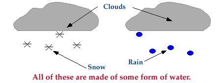
Clouds, snow, and rain are all made of up of some form of water. A cloud is comprised of tiny water droplets and/or ice crystals, a snowflake is an aggregate of many ice crystals, and rain is just liquid water.

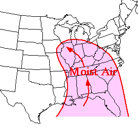
Water existing as a gas is called water vapor. When referring to the amount of moisture in the air, we are actually referring to the amount of water vapor. If the air is described as "moist", that means the air contains large amounts of water vapor. Common sources of moisture for the United States are the warm moist air masses that flow northward from the Gulf of Mexico and western Atlantic Ocean as well as the moist Pacific air masses brought onshore by the westerlies.

As cyclones move eastward from the Rocky Mountains, southerly winds ahead of these storm systems transport the warm moist air northward. Moisture is a necessary ingredient for the production of clouds and precipitation.


Cloud Types


High, middle and low-level clouds, vertically developed clouds, plus some less common cloud types.


Clouds are classified into a system that uses Latin words to describe the appearance of clouds as seen by an observer on the ground. The table below summarizes the four principal components of this classification system (Ahrens, 1994).

Latin Root
Translation
Example
cumulus
stratus
cirrus
nimbus

heap
layer
curl of hair
rain

fair weather cumulus
altostratus
cirrus
cumulonimbus

Further classification identifies clouds by height of cloud base. For example, cloud names containing the prefix "cirr-", as in cirrus clouds, are located at high levels while cloud names with the prefix "alto-", as in altostratus, are found at middle levels. This module introduces several cloud groups. The first three groups are identified based upon their height above the ground. The fourth group consists of vertically developed clouds, while the final group consists of a collection of miscellaneous cloud types.


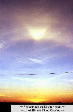
Photograph by: Knupp
High-Level Clouds
High-level clouds form above 20,000 feet (6,000 meters) and since the temperatures are so cold at such high elevations, these clouds are primarily composed of ice crystals. High-level clouds are typically thin and white in appearance, but can appear in a magnificent array of colors when the sun is low on the horizon.


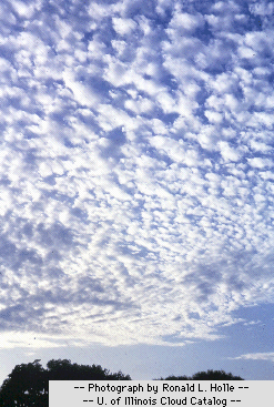
Photograph by: Holle
Mid-Level Clouds
The bases of mid-level clouds typically appear between 6,500 to 20,000 feet (2,000 to 6,000 meters). Because of their lower altitudes, they are composed primarily of water droplets, however, they can also be composed of ice crystals when temperatures are cold enough.

Low-level Clouds
Low clouds are of mostly composed of water droplets since their bases generally lie below 6,500 feet (2,000 meters). However, when temperatures are cold enough, these clouds may also contain ice particles and snow.


Photograph by: Holle

Vertically Developed Clouds
Probably the most familiar of the classified clouds is the cumulus cloud. Generated most commonly through either thermal convection or frontal lifting, these clouds can grow to heights in excess of 39,000 feet (12,000 meters), releasing incredible amounts of energy through the condensation of water vapor within the cloud itself.


Photograph by: Holle

Other Cloud Types
Finally, we will introduce a collection of miscellaneous cloud types which do not fit into the previous four groups.

Classifications
Last Update: 07/09/97
High-Level Clouds
Cloud types include: cirrus and cirrostratus.

Mid-Level Clouds
Cloud types include: altocumulus, altostratus.

Low-Level Clouds
Cloud types include: nimbostratus and stratocumulus.

Clouds with Vertical Development
Cloud types include: fair weather cumulus and cumulonimbus.

Other Cloud Types
Cloud types include: contrails, billow clouds, mammatus, orographic and pileus clouds.


Precipitation


Rain, snow, hail, sleet and freezing rain.


Photograph by: Norene McGhiey

When cloud particles become too heavy to remain suspended in the air, they fall to the earth as precipitation. Precipitation occurs in a variety of forms; hail, rain, freezing rain, sleet or snow. This portion of the Clouds and Precipitation module focuses on precipitation and has been organized into the following sections.

Sections
Latest Update: 07/21/97
Rain and Hail
Atmospheric conditions that lead to the development of rain and hail.

Freezing Rain
A detailed look at freezing rain, associated dangers and the conditions that lead to its development.

Sleet
Atmospheric conditions that lead to the development of sleet.

Snow
Atmospheric conditions that lead to the development of snow.

Acknowledgments
Those who contributed to the Precipitation sections of the Clouds and Precipitation module.

The navigation menu (left) for this section is called "Precipitation" and the menu items are arranged in a recommended sequence, beginning with this introduction. In addition, this entire web server is accessible in both "graphics" and "text"-based modes, a feature controlled from the blue "User Interface" menu (located beneath the black navigation menus). More information about the user interface options, the navigation system, or WW2010 in general is accessible from About This Server.


Acknowledgments


Those who contributed to the development of this module.


WW2010 Personnel (Clouds):
Steven E. Hall - Content Developer and Editor - Scanned in slides, constructed original text and diagrams. Responsible for new layout, organization and cross linking of helper pages. Implemented text and graphics modifications as recommended by the Content Reviewers.

John Walsh - Content Reviewer - Professor of Atmospheric Sciences who edited module text and diagrams for scientific accuracy.

Ken Beard - Content Reviewer - Professor of Atmospheric Sciences who edited module text and diagrams for scientific accuracy.

Mythili Sridhar - Graphics Assistant- Graphically enhanced previous version of this module.

Yiqi Shao - HTML Programmer and Graphics Assistant - Helped with the integration of this module into the WW2010 format and constructed home page graphic.


The navigation menu (left) for this module is called "Clouds, Precipitation" and the menu items are arranged in a recommended sequence, beginning with this introduction. In addition, this entire web server is accessible in both "graphics" and "text"-based modes, a feature controlled from the blue "User Interface" menu (located beneath the black navigation menus). More information about the user interface options, the navigation system, or WW2010 in general is accessible from About This Server.